Levee Enlargement/Berm Project
WHY ENLARGE OUR EXISTING LEVEES?
The levees in place along the Mississippi River are critical factors in the safety of residents of the Delta. As the last barrier between many homes and farms and the wrath of flood waters, it is crucial that these levees be maintained and improved upon as needed.
The U.S. Army Corps of Engineers (Corps) determined during and following the 1973 flood that the efficiency of the Mississippi River to discharge the Project Design Flood had declined drastically. This was evidenced by the fact that comparable volumes of discharge measured at gauging stations in the Vicksburg and New Orleans districts were at higher stages than had been previously noted or predicted.
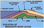
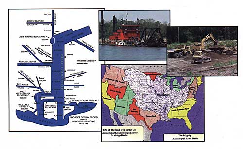
Immediately following the 1973 flood, the Corps completed studies and prepared what is now known as the Refined 1973 Project Flowline, which required an extensive levee enlargement program, some up to 8 feet in height in order to provide a 3 feet freeboard above the newly established project flowline. The project flowline is computed on a volume of water that would be created by a series of storms, which would provide the greatest flood having a reasonable probability of occurrence.
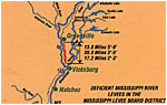
The levee enlargement program in the MS Levee Board district includes 69 miles of deficient levee beginning just below the Greenville Bridge and extending to the lower end of the district with a maximum enlargement being in the vicinity of Mayersville, MS. Some short reaches of seepage berms located north of Greenville also remain part of the program.
CONFRONTING CHALLENGES
While the facts made the need for levee enlargement abundantly clear, some organizations still stated opposition to the programs.

As the Mississippi Levee Board began acquisition of right-of-way for two berm jobs south of Fitler, MS in 1995, the U.S. Fish & Wildlife Services questioned the adequacy of the 1976 Environmental Impact Statement (EIS) for the Levee Enlargement Project, citing changes in environmental policy and other issues as their reasons for objecting. The following private environmental groups, National Wildlife Federation, Mississippi Wildlife Federation, Sierra Club, through its Delta and Mississippi Chapters, American Rivers, Arkansas Wildlife Federation, Louisiana Wildlife Federation and the MS River Basin Alliance retained the environmental watchdog group Earthjustice Legal Defense Fund in 1996 to sue the Vicksburg District Corps of Engineers challenging the adequacy of the levee portion of the 20-year old Environmental Impact Statement (EIS) for the Mississippi River & Tributaries Project (MR&T). The Board of Mississippi Levee Commissioners and the Board of Levee Commissioners for the Yazoo- Mississippi Delta intervened in the lawsuit on behalf of the Mississippi citizens protected by the levee. In 1999, the Vicksburg District and the Levee Boards prevailed in this litigation held in the United States District Court for the Eastern District of Louisiana. The Plaintiffs-Appellants appealed this judgment, but the Fifth Circuit Court of Appeals upheld the ruling in favor of the Corps and the Levee Boards in 2000. Thus, the necessity and importance of the projects for citizens of the Delta was made clear.
DESIGNED TO PROMOTE ENVIRONMENTAL BENEFITS
Great care is given to the creation and implementation of borrow area and berm design. Traditional borrow areas are located on the riverside of the levee adjacent to the construction. The Supplemental Environmental Impact Statement (SEIS) resulted in an alternative that uses open land with suitable material located in the batture (area between the levee and the river) if available within a reasonable distance. In the past, borrow areas were rectangular shaped pits that held water. Today, the Corps of Engineers, working with the Levee Board and the landowner, will often design two types of borrow areas:
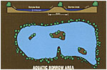
- Aquatic Borrow Areas. This borrow area is irregularly shaped with smooth side slopes, varying depths and islands with trees left undisturbed in the middle. This type design promotes aquatic, fisheries and waterfowl benefits.
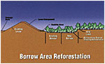
- Reforested Borrow Areas. This borrow area is graded to drain and is planted in trees restoring bottomland hardwoods and terrestrial wildlife habitat. Schematic: Corps Reforested Borrow Area Schematic Photo: Completed Reforested Borrow Area (?)
INNOVATIVE "AVOID & MINIMIZE" DEISGN TECHNIQUES
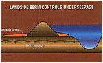
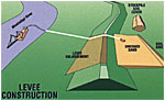
To minimize impact on surrounding land and habitat, seepage berms are located adjacent to the landside slope of the levee to reduce the hydraulic pressure of water passing through the sand layers under the levee. If seep water is allowed to exit the ground with high velocities, it will displace material, causing cavities and voids to form under the levee, which can cause a levee failure (crevasse). Seepage berms are very wide, thus requiring a tremendous amount of borrow material. To reduce the amount of borrow, the Corps of Engineers has developed several innovative "avoid & minimize" design techniques. These designs help avoid and minimize damage to the environment (trees, wildlife and right-of-way acquisitions).
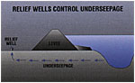
- Relief Wells: Where conditions exist, such as limited landside right-of-way (r.o.w.) and lack of traditional riverside borrow area, the Corps will evaluate the installation of relief wells instead of constructing berms. Relief wells allow for the orderly discharge of seep water through a controlled mechanism without the displacement of material from under the levee. Relief wells are installed adjacent to the landside toe of the levee, thereby reducing r.o.w. acquisitions required by traditional berms, as well as the borrow areas required for the material.
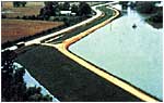
- Dredged Berms. In areas with existing berms that have suitable material with the Mississippi River being close enough to provide an economical source of sand, the Corps is excavating these berms and using the material to raise the levee. Dikes are constructed around the limits of the berms to retain the water, while sand from the Mississippi River is pumped in using a hydraulic dredge. Once the sand is up to grade, the dike material is used to cover the sand berm to provide suitable material to grow the grass cover.
Traditional borrow levee enlargements cost between $1 million and $2 million per mile while the environmentally friendly dredge jobs cost about $3 million per mile. Based upon current funding levels, the MR&T Project is scheduled for completion in 2031.
As of 2001, the Mississippi Levee Board currently has 18.1 miles of deficient levee enlargement and berms under contract (7.6 miles traditional and 10.5 miles dredge). By 2003, another 17.3 miles of our deficient levee will be under contract (8.5 miles traditional and 8.8 miles dredge). These projects will enlarge the most seriously deficient levees to protect the citizens who live behind the levee.
CONSTRUCTING FOR OUR FUTURE
The Mississippi Constitution charges the Levee Boards with responsibility to provide protection of lives and property to the citizens of the delta from floods from the Mississippi River. Following the Great Flood of 1927, and the acknowledgment that 41% of the continental United States drains down the Mississippi River to the Gulf of Mexico, Congress passed the Flood Control Act of 1928. This Act recognized that flooding due to the Mississippi River is a federal responsibility. A portion of this Act called for uniform earthen levee construction along the Mississippi River. Prior to 1973, the levee was essentially up to grade. However, following the 1973 Flood, the Project Design Flowline was revised upward, thus necessitating an extensive levee enlargement program to provide the protection as mandated by Congress in the 1928 Act. These levee enlargement projects are part of the Mississippi Levee Boards long history of flood protection in cooperation with the Corps of Engineers.